1960 Anscombre Pictorial Map of Plants and Animals of North America and Asia 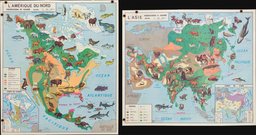 WE SELL ONLY ORIGINAL ANTIQUE MAPS - NOT REPRODUCTIONS Title: LAmérique du Nord Végétation et Faune. / LAsie Végétation et Faune. Description: This is a 1960 Jean Anscombre double-sided pictorial map of the plants and animals of North America and Asia. The map depicts North America from the Pacific Ocean to the Atlantic Ocean and from the Arctic Ocean to northern South America and Asia from Europe and East Africa to the Pacific Ocean and from the Arctic Ocean to the Indian Ocean and Indonesia. Strikingly colored and wonderfully illustrated, both maps feature portraits of the animals native to these continents, each identified by the French name. Some of the species illustrated in North America include the moose, beaver, raccoon, mountain goat, pronghorn antelope, bison, bald eagle, jaguar, and giant anteater. In Asia, the wolverine, polar bear, Mandarin duck, golden pheasant, Indian rhinoceros, sun bear, pangolin, yak, snow leopard, and giant panda make an appearance. The vegetation present on both continents is illustrated through the use of colors that correspond to legends situated on the right of both maps. Each color represents a different zone of vegetation. Inset maps, situated, respectively, in the lower right corner of the map of Asia and the lower left corner of the map of North America the climate throughout both continents, complete with average amounts of precipitation, average temperatures, wind directions, and ocean currents. Publication HistoryThis map was created and published by Jean Anscombre and La Maison des Instituteurs in 1960 and printed by the Imprimeries Oberthur.Size: Printed area measures 31.75 inches high by 36 inches wide. Condition: Very good. Laminated. Map of North America on one side map of Asia on the other. Four gommets present on map originally used for display purposes in classroom. Shipping: Shipping rates are not negotiable. Items are shipped within three business days of receiving payment. We are happy to consolidate shipping where possible. The following shipping options are available: 1. FedEx Overnight (45 USD). USA Only. Signature Required. Customs: International buyers are responsible for paying duty and taxes on delivery. DHL or FedEx will contact the buyer by telephone to arrange tax payment if it is levied. Duty varies by country and we cannot predict the amount you will be charged. Some countries are duty free, others are not. Typically, a customs duty and/or VAT tax will be assessed on all parcels to continental Europe. Sometimes duty or tax is due in China, but is seems very random. Hong Kong, Singapore, Korea, and Taiwan have never assessed duty on a map we shipped. Maps shipped to the UK should be duty free as educational materials, but from time to time duty of 5% is assessed incorrectly by the UK customs agents. Insurance: All shipments are insured privately against loss and damage. All of our shipments require a signature for insurance purposes. If you have any questions please feel free to email us through eBay. Other Services Conservation Framing: Geographicus recommends basic conservation framing services for any antique paper. We do not offer this service. |

1960 Anscombre Pictorial Map of Plants and Animals of North America and Asia WE SELL ONLY ORIGINAL ANTIQUE MAPS - NOT REPRODUCTIONS Title: LAmérique du Nord Végétation et Faune. / LAsie Végétation et Faune. Description: This is a 1960 Jean Anscombre double-sided pictorial map of the plants and animals of North America and Asia. The map depicts North America from the Pacific Ocean to the Atlantic Ocean and from the Arctic Ocean to northern South America and Asia from Europe and East Africa to the Pacific Ocean and from the Arctic Ocean to the Indian Ocean and Indonesia. Strikingly colored and wonderfully illustrated, both maps feature portraits of the animals native to these continents, each identified by the French name. Some of the species illustrated in North America include the moose, beaver, raccoon, mountain goat, pronghorn antelope, bison, bald eagle, jaguar, and giant anteater. In Asia, the wolverine, polar bear, Mandarin duck, golden pheasant, Indian rhinoceros, sun bear, pangolin, yak, snow leopard, and giant panda make an appearance. The vegetation present on both continents is illustrated through the use of colors that correspond to legends situated on the right of both maps. Each color represents a different zone of vegetation. Inset maps, situated, respectively, in the lower right corner of the map of Asia and the lower left corner of the map of North America the climate throughout both continents, complete with average amounts of precipitation, average temperatures, wind directions, and ocean currents. Publication HistoryThis map was created and published by Jean Anscombre and La Maison des Instituteurs in 1960 and printed by the Imprimeries Oberthur.Size: Printed area measures 31.75 inches high by 36 inches wide. Condition: Very good. Laminated. Map of North America on one side map of Asia on the other. Four gommets present on map originally used for display purposes in classroom. Shipping: Shipping rates are not negotiable. Items are shipped within three business days of receiving payment. We are happy to consolidate shipping where possible. The following shipping options are available: 1. FedEx Overnight (45 USD). USA Only. Signature Required. Customs: International buyers are responsible for paying duty and taxes on delivery. DHL or FedEx will contact the buyer by telephone to arrange tax payment if it is levied. Duty varies by country and we cannot predict the amount you will be charged. Some countries are duty free, others are not. Typically, a customs duty and/or VAT tax will be assessed on all parcels to continental Europe. Sometimes duty or tax is due in China, but is seems very random. Hong Kong, Singapore, Korea, and Taiwan have never assessed duty on a map we shipped. Maps shipped to the UK should be duty free as educational materials, but from time to time duty of 5% is assessed incorrectly by the UK customs agents. Insurance: All shipments are insured privately against loss and damage. All of our shipments require a signature for insurance purposes. If you have any questions please feel free to email us through eBay. Other Services Conservation Framing: Geographicus recommends basic conservation framing services for any antique paper. We do not offer this service. |

